Blog Exercise Nine
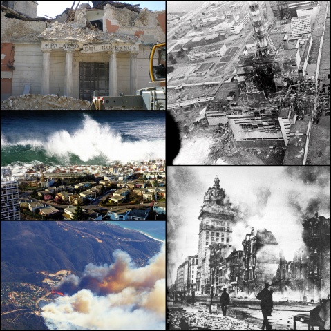
Picture one of this blog depicts the destruction of built infrastructure, most likely brought about by an earthquake. Earthquakes tend to have a wide spread impact and risk. Earthquakes involve movement of the earth and can happen on slip faults, subduction zones, dormant plate boundaries, and through continental collision. Earthquakes can be magnified by the build-up of silt and sediment which can cause liquefaction of the soil. Earthquakes happen most often at the Ring of Fire, near the Mediterranean, and in central Asia. The impact of an earthquake is determined by the depth of the earthquake, that is, how far down the location of its hypocenter is from its epicenter. The hypocenter is located underground, where the energy in the rock is released, and the epicenter is located directly above the hypocenter, on the earth’s surface, where the impact of the earthquake is the greatest. Other factors that determine the impact of an earthquake include the magnitude of the earthquake’s seismic waves, and human activity, which turns an earthquake from a hazard to a risk. The magnitude is measured by the Richter scale which ranges from zero to nine, though there is no real max magnitude. There is no known solution to prevent an earthquake from happening, but there are ways to mitigate the risk. Seismologists who monitor earthquake activity can often warn people located in areas at risk. Other mitigating measures include creating safe zones, building emergency services not located on top of faults, adjusting building codes to have earthquake proof architecture, and creating policies to turn off gas lines in the case of an earthquake. Picture three of this blog depicts a tsunami crashing over coastal land and infrastructure. Tsunami’s are caused by earthquakes or displacement on surface or subsurface. Building infrastructure along the coast increases the risk of a tsunami. Like earthquakes, tsunamis cannot be prevented, but there are ways to mitigate the risks such as: warning systems, education, and support from emergency responders are the only ways to mitigate. Picture three illustrates a massive fire consuming settlements and urban fringe on the edge of forest. Fires are caused by drought, arson, lightning, urban expansion, and land management. At the edge of a forest, picture four exhibits the increased dangers building in forest surrounded areas because they are fire prone. Picture four appears to be an example of air pollution in an urban setting. Given the setting of the photograph, it is likely that the air pollution was from anthropomorphic causes like industrial waste and fuel combustion. Where there is such an extreme amount of industrial waste there is often water pollution from leakage of barrels and pipes chemicals and improper drainage of toxic waste. The buildings appear to be degraded, as is likely corrosion that is a consequence of both water and air pollution. Picture two displays a building that has been subject to an explosion, possibly due to a nuclear reaction. Nuclear power is lethal in both the short term as well as long term if it escapes into the air, rather through accidents at testing facilities or if used as a weapon.
The usual rules…don’t attempt to identify the particular disaster, just talk about hazard and risk in each of these instances…

Recent Comments