Blog Exercise Nine
Picture one of this blog depicts the destruction of built infrastructure, most likely brought about by an earthquake. Earthquakes tend to have a wide spread impact and risk. Earthquakes involve movement of the earth and can happen on slip faults, subduction zones, dormant plate boundaries, and through continental collision. Earthquakes can be magnified by the build-up of silt and sediment which can cause liquefaction of the soil. Earthquakes happen most often at the Ring of Fire, near the Mediterranean, and in central Asia. The impact of an earthquake is determined by the depth of the earthquake, that is, how far down the location of its hypocenter is from its epicenter. The hypocenter is located underground, where the energy in the rock is released, and the epicenter is located directly above the hypocenter, on the earth’s surface, where the impact of the earthquake is the greatest. Other factors that determine the impact of an earthquake include the magnitude of the earthquake’s seismic waves, and human activity, which turns an earthquake from a hazard to a risk. The magnitude is measured by the Richter scale which ranges from zero to nine, though there is no real max magnitude. There is no known solution to prevent an earthquake from happening, but there are ways to mitigate the risk. Seismologists who monitor earthquake activity can often warn people located in areas at risk. Other mitigating measures include creating safe zones, building emergency services not located on top of faults, adjusting building codes to have earthquake proof architecture, and creating policies to turn off gas lines in the case of an earthquake. Picture three of this blog depicts a tsunami crashing over coastal land and infrastructure. Tsunami’s are caused by earthquakes or displacement on surface or subsurface. Building infrastructure along the coast increases the risk of a tsunami. Like earthquakes, tsunamis cannot be prevented, but there are ways to mitigate the risks such as: warning systems, education, and support from emergency responders are the only ways to mitigate. Picture three illustrates a massive fire consuming settlements and urban fringe on the edge of forest. Fires are caused by drought, arson, lightning, urban expansion, and land management. At the edge of a forest, picture four exhibits the increased dangers building in forest surrounded areas because they are fire prone. Picture four appears to be an example of air pollution in an urban setting. Given the setting of the photograph, it is likely that the air pollution was from anthropomorphic causes like industrial waste and fuel combustion. Where there is such an extreme amount of industrial waste there is often water pollution from leakage of barrels and pipes chemicals and improper drainage of toxic waste. The buildings appear to be degraded, as is likely corrosion that is a consequence of both water and air pollution. Picture two displays a building that has been subject to an explosion, possibly due to a nuclear reaction. Nuclear power is lethal in both the short term as well as long term if it escapes into the air, rather through accidents at testing facilities or if used as a weapon.
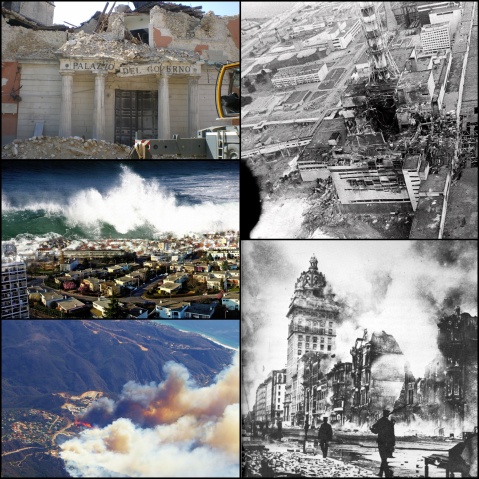
The usual rules…don’t attempt to identify the particular disaster, just talk about hazard and risk in each of these instances…
Blog Exercise Eight….
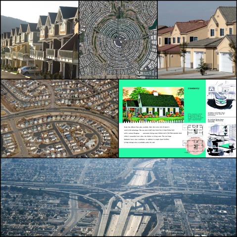
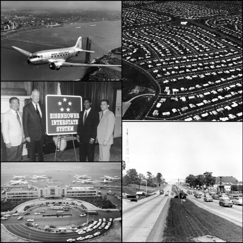
After World War II the United States government made a massive investment in infrastructure through providing cheap government mortgages to increase the amount of home owners. The government encouraged homeownership in efforts to prevent communism and socialist ideologies in America. The The government encouraged homeownership not only through subsidized infrastructure, but also through spreading and promoting the idea of the American Dream. The American Dream not only included a dream for a single family home at a cheap price, but also a dream to have everything that goes in it. Since the affordability of homes went up, more people had disposable income to spend on stuff to fill their homes. The increase in spending led to an economic boom with an explosion of retail, entertainment, other various customer services. The American Dream instigated the need to move away from the city to have a private property and private green space, which is not common in the city. In order to move out of the city America prioritized the need for cars and highways, seeing cars as an American’s way to freedom, while public transport becomes nonviable economically. However, freedom for every family of every blue-collar worker through car access came at a price. The convenience of the car led to roads designed wide enough for cars travelling 50 miles an hour with parallel parking. Subdivisions were designed to drive home and drive-out of, but not for social interaction. Historically sidewalks were not requires which meant there was no place safe to walk. Without walking, obesity rates shot up. The car-friendly design of subdivisions proved dangerous for children living and playing next to the streets and led to kids being killed by cars. And with the invention of 24 hour news filled with child abductions, these things caused a culture of fear to break out. Isolation was their solution through a combination privacy fencing, solely scheduled interaction of kids, prohibition of children bicycling, gated communities and cul-de-sacs. All that privacy and isolation only caused the source of the problems to go from external forces to forces from inside the home. Isolated kids became dangerous themselves through prescription drug use and drug dealing, stealing, and vandalism. Without social capital in the community people do not feel responsible to stop the crime that goes on outside their doors, and if it starts to bother them they just leave. But the damage was not bound to the suburbs. The desire and ability to obtain the American Dream resulted in what is known as the Urban Flight. Those who could leave the city and those who could not paid dearly for their inability. People with money moved out of the cities and their money left with them leading to an industrial decline inside the city. The city became an urban donut, unable to revitalize itself. Meanwhile, tax payers’ money goes to paying for road, electricity, and sewer/water main construction to increase people’s ability to sprawl since the cost per person sky rockets. Tax rates also go up because property costs are lower. The subsidized infrastructure desired by the people living in low density environments was being paid for by people living in denser environments. The people living in denser environments cannot afford to pay the extreme taxes for building the roads let alone the maintenance of them. The unforeseen issue with the expansion of highways is that the more highways built, the more traffic congestion. Transportation costs also increase due to the longer commute time. The commute time has an inverse effect on the work productivity and family time. Increased commuting time is also an environmental hazard as it massive amount of pollution.
Blog Exercise Seven
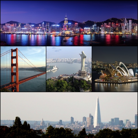
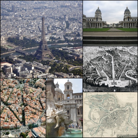
The pictures represented above all have one major thing in common, and that is the presence of icons in global cities. Some icons are architectural and some are geographical, but they all are used to make the city stand out as unique from other cities around the world. Often times cities are distinguished by their historical icons such as the Colosseum in Rome, Italy, and other times modern day constructions such as the Sydney Opera House in Sydney, Australia, are the prime identifying factors of a city. Some iconic structures are physically usable and serve a functional purpose, while others have no direct functional purpose. The structures that have no functional purpose inherit only nonfunctional purposes, such as symbolic reference, although both functional and nonfunctional icons have the nonfunctional purpose of serving to mark for a particular city as some identifier of itself to the rest of the world. San Francisco Golden Gate Bridge in California, which opened in 1937 and is associated with the architectural style of Art Deco, is an example of a city icon with a functional purpose, that is, to allow travel from Marin County to San Francisco. The Brazil statue on Corcovado Mountain in Rio De Janeiro is a nonfunctional icon for the city. The statue is of Christ the Redeemer and is a symbol for Brazilian Christianity. Like the Golden Gate Bridge, the statue is of the Art Deco style. It is one of the largest statues in the world and its size gives it greater distinction, making it more iconic. The top image is either taken on the southern shore of Tsim Sha Tsui, Kowloon or on the Victoria Harbor facing Wan Chai, the metropolitan area on the northern part of Hong Kong Island in China. As of January 2004, it is called the “Symphony of Lights” because of a multimedia light show that is performs with LEDs and lasers from in and outside of the building along the coast. This city sky line is iconic in itself and yet the city also has an iconic mountain range behind it, a harbor, and particular architectural features, which are each icons in themselves that help identify Hong Kong through their image. These iconic architectural features include: the Hong Kong Convention and Exhibition Center that stands out on the water of the Victoria Harbor with the city set back from it, and the International Center that is the 6th tallest building in the world at 484 meters tall. The Shard London Bridge in London stands at 306 meters tall, ranking at number eleven for the tallest building in the world. However, its height is not the only thing that makes it distinguishing. With the many extremely tall skyscrapers out in cities all over the world, what makes this building distinguished is its pointy pyramid like shape that is unique to all buildings around it and can be greatly differentiated from any other building around the world. All these cities have used these icons as ways to make themselves visually distinguishable and unique from other cities.
Hey there, usual rules, but wait until after Thursday’s lecture to try to respond to this one…I will get the last couple graded by the end of this week…
Blog Exercise Six
Social housing is a type of public housing that is affordable to low and middle-income workers because of the limited rent fees and subsidized funding. Though there are differences between countries when it comes to the kinds of social housing provided, the countries of Europe have much in common when it comes to their involvement with social housing since the turn of the 20th century. According to Kathleen Scanlon and Christine Whitehead, “The first ‘social’ housing initiatives were taken not by local or state authorities but by private actors such as companies, factory owners and philanthropists”. Social housing was mostly taken advantage of in industrial societies and cities to deal with overcrowding, mass poverty, and unhealthy living conditions. At the turn of the 20th century, many housing acts in Europe were passed in an effort to fight social injustice, for the health of the public and to prevent uprisings. Though the housing acts were passed at the turn of the century, for the most part social housing was not built in large numbers until after World War I due to the political and economic turbulence of the war. Even still the majority of social housing projects were funded by the private sector over the public sector all the way up until the end of World War II. The social housing system was picky in its selection of who qualified, primarily being offered only to working class citizens. The system had often come with housing inspectors who were used as a form of control, inspecting rooms and teaching tenants the right behavior while living in such social housing. After World War II, there was a boom in housing construction including social housing, in which the government played a more crucial role than before. In France, the 1% Law of 1953 established a co-op initiative between the government and industry to invest in social housing for all companies that had over 50 employees. Much of the construction was spurred by the need to rebuild in places that had been demolished by the war, specifically war-damaged urban areas, as well as to accommodate for the baby boom. Government increased productivity of social housing construction by placing subsidies on building materials. From the 1950s to the 1970s social housing increased making it known as the Golden Age of Social Housing. The period was characterized by economic gain for not just the wealthy, but also most of the working class. It provided greater economic security to the middle class and allowed for upward mobility. However, the decline of efforts and support of social housing began in the 1970s in France as well as other European countries with a withdrawal of government funding and turn towards owner occupation. Though the private sector and housing organizations took up responsibilities that the government left behind, by the 1990s, social housing had become stigmatized by individualized ideology and fragmentation. Today, though there is social housing in Europe, its supply and funding is disproportionately lacking compared to the number of people who qualify for it. It is also marginal in size compared the rest of the housing sector as there its subsidy funding has been transferred to funding private home ownership.
Primary Source:
http://www.lse.ac.uk/geographyAndEnvironment/research/london/pdf/Social%20Housing%20II/Social_Housing_in_Europe_II_A_review_of_policies_and_outcomes.pdf
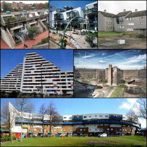
These are all images of social housing projects in Europe…discuss (both the images and the history, execution and success of such projects)…
Blog Exercise Five
In trying to bring people out of the Depression during the 1930s, multiple pieces of legislation (the New Deal) were passed including the National Housing Act of 1934 which created the Federal Home Administration (FHA) and the Federal Savings and Loan Insurance Corporation. The FHA gave homeowners the ability to refinance homes as well as guaranteed that a mortgage will be paid. In the years following WWII there were major repercussions on politics, public policy, and family structure due to the impact of increasing production and ownership of cars, which in turn began to dramatically change the United States urban landscape. With the ability to travel longer distances in shorter time, among other reasons, many people seized at the opportunity to get out of the city and the car was that opportunity. At the end of the war, the GI bill was passed which offered veterans low down payment mortgages with low interest rates. There were 3 more housing acts, two of which (1949, and 1954) expanded veteran and FHA mortgage insurance and issuance and public housing construction. The last Housing Act (1957) restricted what one could buy for a mortgage loan to only modern houses and homes in place that create construction and road jobs, thus, encouraging suburbanization and discouraging renovation of old city houses. In efforts to get more people to buy cars, car industries influenced the taking down and prevention public transportation facilities. The public transportation of cities was sacrificed for mass auto-oriented suburbanization and mass producing interstates. Local city governments gave up control over development of local metropolitan freeways to state governments because they could not get enough funding through tax revenue to build the projects necessary to relieve the ever increasing traffic congestion in inner cities. Largely influenced by engineers who lived in rural areas, state government plans prioritized rural to urban migration over inner city travelling, and because of this, the city suffered by being dissected with freeways, displacement of homes and businesses, and lowering property values.
The Highway Trust Fund was formed by politicians, federal highway officials, and members of industries such as construction to guarantee that the revenue of excise taxes such as fuel would be only spent on the construction and maintenance of freeways/highways. The Dwight D. Eisenhower National System of Interstate and Defense Highways gave incentive and financial support to the building of an interstate highway system during the 1950s. The federal government also matched the state spending on highways at a 9:1 ratio for the building of interstate highways which only encouraged a focus on interstate highway over other forms of transit. As to limit the amount of interstate highway from getting out of hand, the federal government put a limit on the amount of roads by capping the sum of their centerline mileage. This action encouraged wider more complicated road systems, which were overall bad for intercity driving compared to other options. However, by the 1970s, interstate construction boom was not ended because of revolt, rather because of a shortage of funding.
The Baby Boom, which began in 1946, along with the ideal of the American Dream fed this mass suburbanization. The mass suburbanization along with redlining and white flight led to the decline of the urban city, and in the 70s 80s and 90s almost all that was left in many American cities were poor minorities with poor health, rampant crime, and drug problems. The picture of the airplane for this blog is of the airline, Canadian Colonial Airways, which was founded in 1929 and it offered the transportation of goods, mail, and passengers from Montreal to Albany to New York. Aviation became another dominate means of transportation in the late 20th century. In 1969 the invention of the Boeing 747 allowed affordable air flight to the masses. In 1970 he airport and Airway trust Fund was created to provide funding to the aviation system through excise taxes.
Prime Soureces:
https://www.boundless.com/sociology/population-and-urbanization/urban-problems-and-policy/suburbanization/
http://www.uctc.net/access/35/access35_Paved_with_Good_Intentions_Fiscal_Politics_.shtml
Usual rules; reblog, 500 word commentary, remember to actually reference the images in your response…
Blog Exercise Four
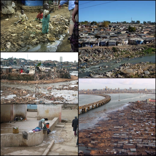
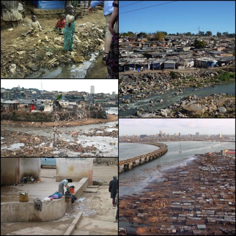
The pictures provided for this blog are of typical Shanty towns in Africa. These are the slums of African cities which are filled with unregulated settlements constructed and inhabited by squatters who cannot afford to own their own land or pay rent. They exist because of a slow economic development that cannot keep up the pace with the unprecedented growth of the population due to high birth rates. The government does not provide these communities with sanctioned services such as water, police, electricity, roads, and schools. These communities are also not taxed by the government. Because there are no government services, there are no governmental regulations or standards placed on the way these people live. The sites of slums are filthy and dangerous. These communities do not have access to clean water or a sewer system. In overcrowded conditions with stand pipe water, these people are often greatly impacted by disease, such as cholera, because of this the unhealthy environment that they live in. Most shanty towns are located on the edges of cities of developing nations on sites that are unwanted by developers because of health and safety hazards or other reasons that make the land have no value or make it unable to be developed. Many of sites of slums are located on swamps, steep hills, industrial areas, trash landfills, river valleys, steep slopes, under highways and other kinds of “uninhabitable” areas. Much of what is considered trash by people, who make money through a formal economy, is scavenged for and used by people in shanty towns as a commodity for trade and source of income. All services for the community are provided by the shanty town’s residents and are under the counter, that is, nontaxed because there is no big market for commercial goods and services. Goods such as thrown out clothing are cleaned off and resold at tables on unpaved paths throughout the slum along with services that make up their informal and unreliable economy. The children of these impoverished families living in slums are put to work with activities such as gathering tradable items from trash piles, instead of receiving a formal education. The housing of slums are make-shift small simple single spaces constructed of various available materials, commonly including corrugated tin, sheets of plastic, plywood, and cardboard boxes. The houses are often settled densely together and would often be considered a fire hazard. Outside of Africa there are many other countries that have slums including India, China, and countries of Latin America such as Brazil. Cities such as San Paulo have slums that have been so oppressed by the government by militarization that the slum communities have transferred their leadership over to drug lords who protect the slum population from the government and provide services to the community. The drug lords use slum communities to hide drug trafficking. Overcrowding in cities, such as Hong Kong, have what might be considered one step above shanty towns because their growth is regulated, these people actually do have access to jobs and health care. Many people are living in mass produced houses, some even in cages that are as big as 6 feet by 2 feet by 3 feet. In some areas shipping containers are piled on top of each and are paid for as rental homes for families. These shipping containers have electricity which is a hazard because the containers are made of metal. The problem in China is not a lacking economic growth or a lacking of industrial development, rather there is no housing/land to accommodate the rampant industrial growth.
Blog Exercise 3
During the 19th and 20th century, economic prosperity attracted unprecedented numbers of foreigners to immigrate to the United States, as industrialization in the U.S. began. The U.S. government conducted a survey of the land to the west in 1796. Under the Homestead Act of 1862, any citizen or immigrant intending to become a citizen could file an application to claim 160 acres of surveyed U.S. Government-owned land, and if they built a 12 by 14 house on the land and lived there for five years the land would become theirs. The Homestead Act of 1862 gave opportunity for citizens and immigrants to settle westward who could not have afforded to buy land otherwise. The U.S. Government wanted people to move West in order to “pascify” the Native Americans and to deal with the increasing number of immigrants. To encourage westward expansion, the government passed the Pacific Railway Act that gave land grants encompassing a section of land that stretched from the Atlantic to the Pacific Ocean to the railroad companies so that the companies would lay down a railroad system all the way across the U.S. The railroad companies sold their unused land and inflated prices. The money obtained from selling the millions of acres of land helped finance the construction of the railroads and then some. With easy access to the cheap land in the West, as well as new and fast way of obtaining manufactured goods (even kit houses) from the east via the railroad and through catalogue companies, westward expansion kicked into gear as the transcontinental railroad had been laid by May 1869. Other incentives to move west, even as far as California, included the California Gold Rush from 1848-1855. The efforts to make the entire U.S. accessible by rail allowed the railway to take over as the main form of transportation in the U.S. (replacing the former transportation means by water). Where ever the railroad went, so did people and this led to the development of many American cities such Chicago and Los Angeles. The prosperity of booming cities in America can often be traced back to their access to railways because the cities and their hinterlands acted as collection and distribution points for manufactured goods. The cities accessible by the railroad grew because the railroad brought people into cities and allowed for the quick transportation of goods in and out of the city, supplying the needs of a large population. With cities being dominated by transportation and industry, the conditions of the inner city began to decline. As the railroad allowed for the creation of great cities, it also allowed the upper-middle class to move out into suburbs which caused the inner city to suffer from no tax base. Four other transcontinental railroads were laid by 1900. The use of railways and the like around and inside cities, such as the underground subway in New York, which started out as a steam railroad, has proven to be useful in that it allows for maximum development of the city above ground without taking up room to provide transportation ways for the massive amount of people living there. With the exception of places like Manhattan, the railroads began to be replaced by cars in the 1930s as the main form of transportation after the Federal-Aid Road Act of 1916. A sharp decline in the use of railroads happened in the 1950s and 60s due to the Highway Trust Fund that financed the Interstate Highway System.

Transport in US cities, 19th and early 20th centuries – discuss. Usual rules apply…five hundred words, outside sources are fine, but must be cited…
Blog Exercise Two
These representations of the Baroque period of European urban development relate to our lectures from this week in multiple ways. Baroque art originated in cities during the late 16th century in Europe, and it manifested itself in different ways throughout Europe. Though the architecture and city layout of Washington D.C. was decided in 1796, after the war for American independence, the capital was still purposefully designed to have much in common with European cities such as Paris. The designer, Pierre Charles L’Enfant was actually French born, and the city was designed to emulate the power of Paris through its architectural appearance and city plan. Both Paris and Washington D.C. were planned in advance to be expressions of power. In Europe, the primary form of Baroque art was architecture, though the public display of art through sculpture and painting was also quite prevalent. Baroque art emulated power in its grandness, extravagance, and organizational aspects. Throughout much of history, the architecture of a city has represented its level of success and power. The Eiffel tower, constructed of iron lattice, acted as an architectural structure as well as a sculpture. It was created for the World’s Fair of 1889 to represent the identity of France as powerful in its innovativeness with advanced technology and design. The power emulated is specifically the power of those in authority, that is to say, those in control of the country. For Washington D.C. this power was to reside with the government. Similarly, the power in France resided with the absolute monarchs of France. In Rome, Baroque architecture symbolized the power of the Roman Catholic Church. However, unlike European countries, the United States was a democracy which meant that the federal government was more limited in its power. The only reason the federal government was able to make Washington D.C. a Baroque city was because it not a part of a state, nor a state itself, but a separate district that is completely under the control of the federal government. Washington D.C. is the only place where the United States federal government has complete control over its land. The Washington D.C. city plan itself seems to relate to Paris more than any other city. Both have uninterrupted wide boulevards that cut horizontally, vertically and diagonally through the entire city, all of which extend out from polluviums that are located on focal points of the city. Focal points of both cities include monuments and political buildings. The unobstructed boulevards create a line of site and allow for fields of view that always direct the eye to structures that signify the political power. In Paris, the boulevards were intentionally made extra wide to allow the army to easily assert control over the city, and to prevent citizens from blockading the streets. Having narrower streets would have made it easier for citizens to blockade them, and harder for armies to break through the blockades. Haussmann’s plan for the renovation of Paris, commissioned by Napoleon III, cut through large chunks the city, removing housing against the will of the masses to put in grand boulevards. The architectural style of the buildings are also the same in both cities, with the white symmetrical facades, domes, and rows of columns.
As last week, please reblog and write at least 500 words about how these representations of the baroque period of European urban development relate to our lectures from this week.
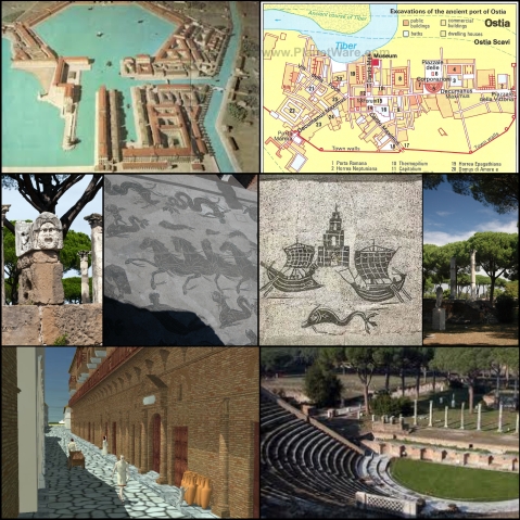
Blog Exercise One
Ostia Antica is an ancient port city located about 15 kilometers southwest of Rome. In 396 B.C., imperialist Rome took control over Ostia Antica as its first colony. Ostia Antica is the Roman city equivalent to the Greek city Miletus in that its ports have been subjected to rising sea levels and sedimentary deposits. The silting of the ports as well as warfare led to the decline and abandonment of both cities. The city of Miletus is located near the mouth of the Maeander River, whereas the city of Ostia Antica is located on the mouth of the Tiber River. Rome depended on Ostia Antica as its major seaport to trade with other cities. This seaport supplemented the trade system of Rome, which had been well developed due to their extensive network of roads that extended far inland. Their roads were stone-paved and allowed for wheeled traffic as well as pedestrian traffic. The gridded city pattern used in Roman cities, such as Ostia Antica, originated at Miletus. The gridded city pattern was made up of roads that ran east-west that were each known as a decumanus, and roads that ran north-south, which were each called a cardo. There were two main roads, the east-west main road was the Decumanus Maximus and the north-south main road was the Cardo Maxiumus. At the intersection of these two roads was the Roman forum of the city, which was the market place and the Roman equivalent to the Greek agora. The ruins of Ostia Anticas’s Roman forum, with its classical columns rising up from the grounds, are shown in the last picture on the second row listed for this blog. Like Miletus, Ostia Antica was home to a theater, which was used by the empire as a means to control the masses by distracting them in the form of entertainment. The amount of similarities between Miletus and Ostia are no surprise as ancient Greece and ancient Rome shared much in common. Though much of the ruins of Ostia Antica have been picked over by people of Middle Ages and Renaissance over the years, such as the Baroque architects who wanted to use the marble for building structures and sculptures in Rome, the site still shows the high cultural importance of art with many sculptures, mosaics, and general adornment to public buildings. The artistic picture of horses and sea creatures (the second picture on the second row) is actually a portion of the mosaic floors of a Roman bath in Ostia Antica. A Roman invention, the public bath was used by the majority of the city’s inhabitants on a daily basis, and like the theater, it was used as a means to prevent an uprising by keeping the citizens of Rome content. The baths, theaters, and roads were all evidence to Rome’s identity as the most advanced technological civilization up to its time. Ostia was not only used as a trade port for Rome, but also as a Roman naval base, which lead to one ship building being one of the city’s specializations.
Please reblog this and write 500 words of discussion about what you see and how it relates to the lecture we had on classical and ancient cities last week. Your thoughts should be posted by midnight on Sunday January 26th. Feel free to comment on each others’ posts…

Recent Comments